Thursday, May 3, 2012

5/3/12 Gaviota Peak


View Larger Map


At the trail head a $2 fee is required, and stern warnings are posted about the presence of mountain lions. It is advised that no one travel alone.
We outfitted the equines with bells and jingled our way onto the trail, heading straight up a 3 mile climb to the top of Gaviota Peak.
 This is the VERY large staging area, just off the intersection of Hwy 1 and Hwy 101. A dozen horse trailers could easily park in it, and it is frequently used by day hikers who park here to use the Gaviota hot springs a short distance up the mountain.
 It is a road, not a trail, and only on a very few areas is it not possible to walk with two animals abreast.
 This is the goal, a peak of the frontcountry range that promises to give a fabulous view up and down coast.
 In early May the goundcover is still lush and green, and today it was bright and not too hot.
 Still it is nice when the trail goes through areas shaded by ancient oaks, very cool.
 The trail splits into two. The left one is the one that we will take, that passes the hot springs and continues to the peak. Off to the right is the Trespass Trail, that I rode last year and found it very overgrown.... we cut our way through dense bushes for quite a ways and then turned around. We did not investigate it this day.
 A steady climb is accomplished by sweeping slow switchbacks, easy for an equine in any condition.
 A very large hawk was intent on feeding on ground squirrels in the field and circled overhead.
 The path continues across the fields, a bit overgrown but always passable.
 The mustard is still in high bloom, and many tiny spring flowers also.
 The landscape seems quite natural, the way California has always looked.
 Off to the East is an area still privately ranched.
 A gate across the trail presumably to inhibit the use of off road machines.
 With the hubris of someone used to riding an equine ATV I walked on the left, around the metal bar, because I saw a slim track on the downhill side.
 Only afterwards when I turned around did I see that a horse path has been carved out of the bank, and circles uphill of the tree. That is the recommended equine trail.
 A gnarled ancient oak at the side of the path.
 A weather-beaten and graffiti covered sign for the Los Padres National Forest.
 We begin to have vistas. This is looking North, across the Hollister Ranch lands toward Jalama Beach.
 But we have miles to go........... onward and upward.
 This is looking down to the part of Hwy 1 that branches off from Hwy 101 and goes North toward Lompoc and Vandenburg Air Force Base.
 Now for the last part of the ascent to the peak it is very steep, single track, and a sweaty push for Mr Mule.
 But we have done it, and we can look out over the front range down to the sea, and the Gaviota coastline to the South. Marine haze and dare we say a bit of Los Angeles smog sully the horizon.
 Tobe is happy to take a breather, and stands quietly enjoying a treat of carrots as the humans have a snack and a stretch.
GAVIOTA PEAK elevation 2458
 A small metal can holds several notebooks filled with the comments of humans who have been here. None seemed to have any empty pages so I will plan to start a new one when I return someday.
 A panorama that shows the trail up, on the left, the ocean view, and my mighty mule Tobe.
 The trail running along the ridge line to the South seems to be the tail of Camino Cielo, and someday I think that would be a fabulous day ride, exploring to see how far we can go on it. The Santa Barbara Trails Council is working hard to clear permissions for all of these coastal trails to connect.
 But for now, time to turn around and start the descent.
 Soon we are back on the wider path, and again looking out to Jalama beach in the far North-West, much obscured by haze.


Another happy adventure with the Mule Team!

Saturday, March 24, 2012

3/24/12 Lake Cachuma

3/24/12 Mule Ride out to Lake Cachuma at Live Oak Camp
3 mules, 3 humans, 3 hours, 6.6 miles


View Larger Map


 A big Arctic Burst storm was predicted, and tax deadlines loomed, and it seemed like a perfect reason to chuck responsibilities and get the mules out on the trail. After all, once you're out in the wilderness all the petty concerns of Real Life are just a memory, and the immediate beauty and challenge are all-engrossing.
 For once it wasn't Tobe and I who were ready last. Otis did circles on Pretty Boy Floyd, and Barbara fussed over Tillie's tack, and then we headed out from the live Oak campground.
 We are incredibly fortunate to have access to this property, where no bicycles or dogs create hazards. There is a lot of wild life, so we never know what we will run into. Off we go!
 Even though it rained hard last week there was barely any water in the river.
 Lake Cachuma glimmering on the horizon is always the high point of the rides here, all paths lead to views.
 Then again, right here Barbara said she knew where a barely visible trail behind an oak tree went, one that looked suspiciously like a cow path, but what the heck, we're on mules, we ride the ATV of the equine world, so lead on!
 It led to a deer hollow! And I think they are MULE deer, see the big ears on that one laying down in the edge of the shade under the oak? It was a family of a dozen or so, they are masters of camouflage.
 Beautiful oaks hung with Spanish Moss, the trunks dark from the recent rains, leaves bright green with new spring growth.
 Then down at the lake level, watching for water fowl and feeling the wind whipping across the water.
 Signs that wild boars have been here, rooting up the grass.
 The wind got stronger, causing whitecaps on the water, and big luminous clouds appeared over the coastal range.
 The clouds advanced rapidly, and the temperature began to drop. And this is exactly WHY we are out here, because tomorrow we'll be cosy indoors and this trip would not be possible.
 Tobe LIVES outdoors 24/7, so whether he's taking me for a stroll or play-fighting with his friends, it is all the same to him. Another day, another field of grass.
 But all of us enjoy the views, as we stop at another promontory to look back across the lake.
 This is a rather Picasso-esque panorama............. I'll practice with this app and do better next time!
But today's ride is done, and time to head back to civilization.

Sunday, February 26, 2012

Montecito Turkey Trot with LPTR

2/25/12
A Turkey Trot Rodeo in Montecito
6 miles
2 hours
2 mules and a horse


View Larger Map

 Tobe waits patiently at the BrenderUp, he knows the Greenwell Preserve, been here, done that. We were asked to go along as a friend did a pre-ride examination of the trail, in advance of leading the local Los Padres Trail Riders on an outing here tomorrow.
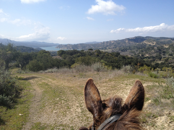
We took the trail to the South, which rises up and immediately gives a view out to sea.
 It was a very hazy day, so the islands on the horizon are just barely visible.
 A lot of this trail is along the edges of estates, and across meadows awaiting development into McMansions.
 If you're not the lead mule.......... you watch a lot of ass.  Here we are strolling down the trail as it cuts through a lemon orchard. If ONLY the internet provided the "Scratch n' Sniff" capacity, and readers could have the heady scent of lemon flowers in bloom on a hot sunny day.
 In back of a very swanky horse facility we saw 
a glimpse of how "the other half lives."

I can't say I have much ambition to have Tobe learn to be a jumper, so we both watched with curiosity the young girls circling around the arena jumping over obstacles.
 And then, we had a run-on with a turkey. Now, I'm all for every rich person being able to do whatever they want to do with their estate, but right adjacent to the trail is a large pen filled with turkeys and I don't know what all else, because the turkeys were more than enough.
 Tobe heard their gobbling as we entered that section of trail, and I confess the rodeo that ensued was SO extreme that I was quite incapable of taking any photographs. The gal on the Percheron dismounted to lead her horse past, and Tobe pulled rank on me and decided that HE was the more astute member of our team and was making the executive decision that we needed to get the heck out of there. He spun around and proceeded to fly back down the rocky trail, nimbly dodging rocks in the path, as I tried to yank him around into a one-rein stop. In perfect duet on my left was Barbara on Tillie mule, neck and neck in the panic sweepstakes.
 I mean, just look at that face. I do agree with Benjamin Franklin that the turkey should have been our national bird, but please, somehow my Kentucky mule has missed being bomb proofed over a charging tom turkey. I know we've seen wild ones, mild flocks minding their own business, but this guy was in full plumage and aggressively charging  towards the fence and Whoa Nellie! off we'd go, Tobe would spin around again and take off.
Eventually after much refusal, insistence, and sashay away we did get past. But I was quite proud of myself, this was NOT something I could have ridden without injury several years ago.
This photo is a place-holder for the turkey zone, I took it just so it would insert into the trail map not too far from the turkey alley.
THIS is exactly why you pre-ride a trail. Since tomorrow's ride was to include inexperienced riders now Barb was in a pickle, and had to start thinking of alternate routes.
 Then we came to this tree which has a story for me. Five years ago when I was just starting to ride Tobe I came on this trail with the Montecito Trails Foundation annual Fund Raiser. I was in a big group of riders and several bees flew out of a hollow log. One stung the gal riding in front of me, and more stung Tobe, who bucked. I distinctly remember looking down and seeing my hand on the horn and thinking "Wow! You rode through a buck!" and then the next thing I knew I was on the ground. He bucked twice.
The woman leading the trail ride told me if I couldn't get right back on and rejoin the group I could find my own way back to the starting point, and she led the group off and LEFT ME sitting under this tree crying. Thanks, Jane Murray, I'll never forget that moment.
But to my rescue came two Mexican gardeners, who held Tobe for me and I climbed up in that tree and remounted and caught up with the group. I had what looked like a black eye on my hip, but I rode the ride. I was beginning to learn to cowgirl up, and also to be wary of who I go on rides with.
 A little further down the trail I saw this raw rebar sticking up out of the vegetation on the side of the trail.
 A landscaping webbing is stretched between them. Just last weekend one of the officers of the BCHC told me he was on a trail when his mule fell against a piece of raw rebar just like this and it poked her so deep in the belly she would have died from peritonitis, so he had to put her down. He asked me to be on the lookout for this specific hazard on trails now, and photo document it, and here was a very long stretch of it!
 This forest is being completely smothered in Cape Ivy. It is an invasive non-native that steals the light and nourishment from other plants. these trees will be destroyed by it if it is not cut back, and many of the area canyons look similar.
 I don't know anything about the history of this odd structure, it looks like an oil derrik rising up out of an old shed.
r
 We came up out of the canyon trail to the edge of the Polo Grounds, and see heavy construction in progress. Having completed the Turkey Trial, motorized equipment and stone masons were no problem. Here are the piles of stones soon to be assembled into a wall bordering the field.
 And there's a section of completed wall.
 Coming out at the edge of the polo grounds, we turned back towards the Greenwell Preserve, which required walking along the road that is frontage to Hwy 101.
 At the power station there is an easement trail that takes us back up into the hills and off the street.
 Once again looking across Summerland, with Santa Barbara in the fogbank upcoast.
 The mountains are probably ten degrees hotter, and above the coastal fog.
 We got back to Greenwell but Barb was thinking she wanted to see alternative trails, and we had some extra time, so we headed up the Edison, which is controlled by a couple who have horse pens there and requires signing a permission slip to cross on the trail. We had signed in advance.
 It is a quiet and lovely trail, and leads to some rigorous climbing nearby.
 But when we got to the horse area a huge truck was dumping a load of sand, with much attendant clatter, and all the equines were watching and jumpy, and we decided enough was enough, time to trek back down.
 There is always another day and another trail.