Saturday, November 21, 2015

11/21/15 Summerland Greenwell Angels Flight with LPTR


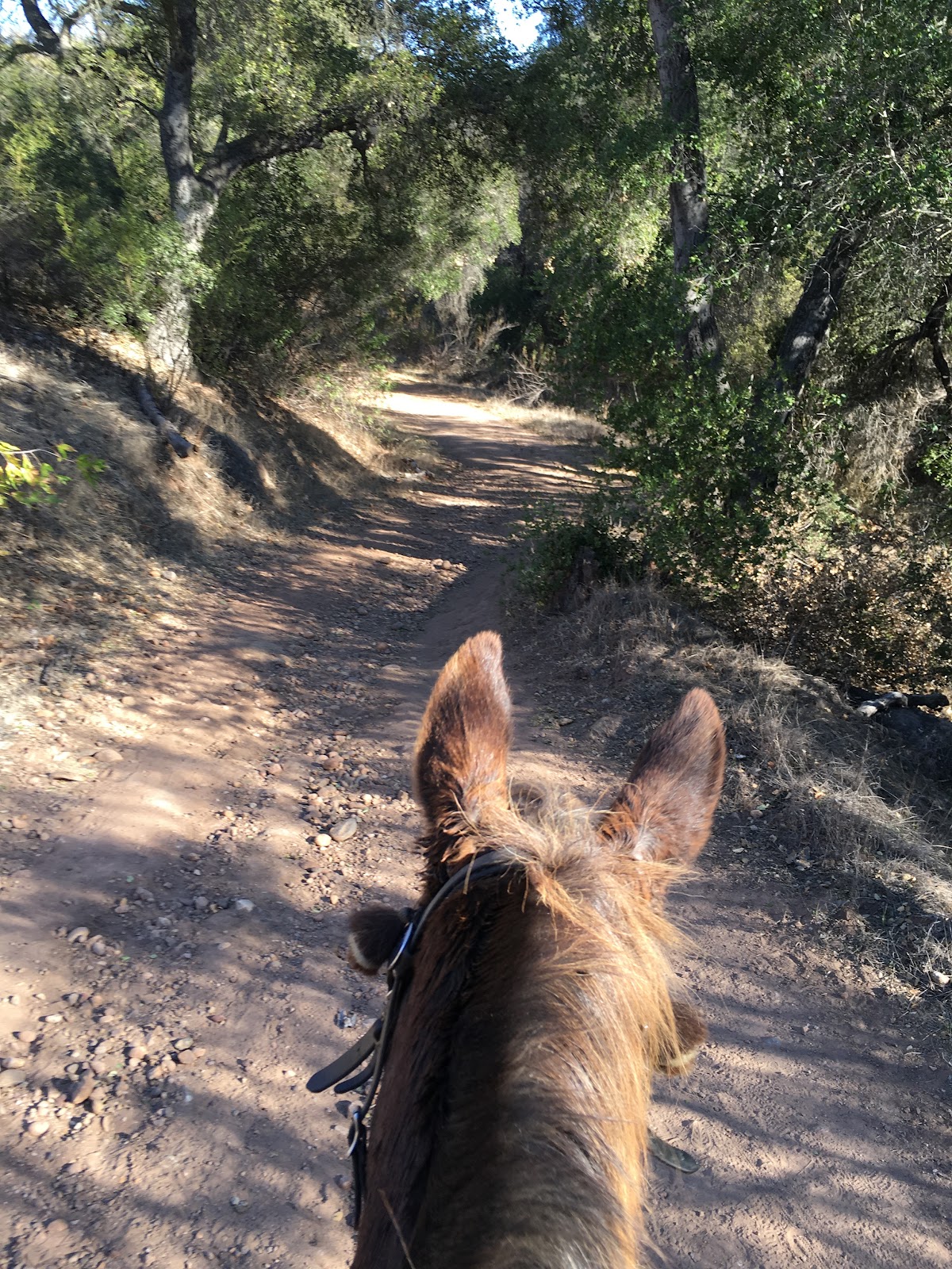
Nothing like starting out in the early morning for a trail ride. The rising sun blazing on the sea, the anticipation of a journey to see a new trail and ride with interesting people on their odd collection of animals.
We met up with a dozen members of the Los Padres Trail Riders at the Summerland Greenwell Preserve. There is a large parking lot that can accommodate numerous rigs, and easy access to many nearby trails.
The route we took was 7.4 miles  and took 3 hours. That was actually a little over 2 hours of moving time, at 3.2mph moving speed, and lots of rest breaks for the animals.
The trail system is maintained by the Montecito Trails Foundation, and connects the sea to the tops of the mountains. We tracked around in the area in the middle, between estates and along the sides of streets, wherever the trail boss decided to lead us to.
Who's the one with the red hair under the sensible helmet? Why, me of course.
Walking through the forests it is easy to see the toll the drought is having, the understory grass is dry tinder and the trees are dropping limbs.
But the shade was most welcome on this Indian Summer day, as we went for our equestrian stroll.
On the high points of hills there are sea views, always a pleasure at the Edge of the Continent.
And in between the massive estates that fill the hilltops there are nice trails, making passage very easy.
The ride was organized by Barbara who rode her new mule Sierra. There were a surprisingly high number of mules on this trip, almost half of the animals. I am used to Tobe being the only mule, so this was a real pleasure. We mule riders can go on and on about The Natural Superiority of Mules, and tend to bond easily with other long ear enthusiasts.
At one vista we stopped at a picnic table for a break, Tobe was already working up a sweat on the 80 degree day. But he's a noble beast of burden, and never faltered in his assigned task.

Sometimes property owners go the extra effort of adding rail fencing, defining their privacy and giving the trails a nice edge.
Often the trail passes through large stands of trees. These eucalyptus were especially fragrant, and where they lean onto the trail are a lovely opportunity to ask Mr Mule to sidepass away from them lest I smash my knee on a trunk. He knows how wide he is, but it is my job to make sure I don't bang a limb on a trunk.

The story is that every week right now the crews are removing another deadfall tree from the Ennisbrook trail. They seem to pretty much cut them up and drop them in place, and we are all hoping that the promised El Niño winter storms will come and save the rest of the forest.
This is an example of the good work done by the work crews of the Montecito Trails Foundation. On the left is a steep drop off to a creek bed. A metal reinforcement has been placed into the slope, and boulders added on this side of it to define the edge and stop further erosion.

And a bit further on we passed across this old stone bridge, wishing there was water underneath it.
Sometimes there is a bump in the road, in this case a boulder in the trail. That's OK. Where there's a mule, there's a way.
But then, what is this? In my previous rides I had never seen this before. It is a memorial to someone unknown. But what a gift to come across it here in the depth of the woods, stark and elegant and so very poignant.
The inscription is from Shakespeare, Hamlet Act 5, Scene 2
"And flights of angels sing thee to thy rest."
A sad epitaph for a sweet prince, one who perhaps loved this forest.
I think this is a California redwood, Sequoia sempervirens.  The bark is amazing.
On the way out and on the way back we passed through this horse boarding facility, owned by the trail boss. Gave the animals a chance for a drink and a rest.
Then it was time to climb the Ortega Ridge hill and go back to the starting point.
One last obstacle, down a steep hill. Not too difficult on the way up, when the animals were fresh and excited about a chance to go for a walk, but a bit of a challenge for many of them as they started down after hours of walking. They zig-zagged down it, trying to find purchase in the dusty dirt.
Off to the side in the avocado grove were many bee hives. As long as none of them got too interested in the sweaty animals, we were OK.
Then we were back at the meeting point, and my pal Cowboy Bob shared an apple with his Dutchess, who deserved a treat after this long ride.
And I'm a happy person, having risen to the challenge of this day's trail and eager to see what will be the next adventure.
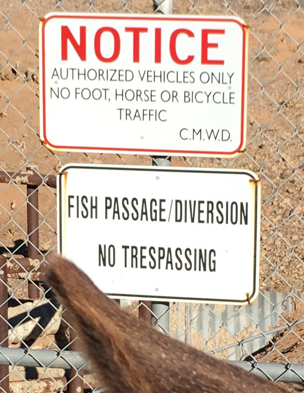
Back to the real world, where the highway is already in progress, and the sign says we can go either way. Time to choose the next path.
As Theodore Roethke wrote:
"Over every mountain there is a path, although it may not be seen from the valley."


Friday, November 13, 2015

11-13-15 Ojai Fish Diversion


5.58 miles in a total of 2 hours moving time
average speed 2.3 mph with one burst of 9.9 mph when we loped a bit
total ascent 684 ft
moderate trail, nothing technical, half of it could accommodate 2 equines walking abreast
well maintained and brushed trail, well signposted
two spring-locked gates that require dismounting and holding open to pass through
Time to load up the little BrenderUp mule trailer and SubUrban and head out to Ojai. I had never gone there to ride, but my pal Cowboy Bob and his mare Dutchess invited Tobe and I to come explore. We met at high noon at the Oso Road trailhead entrance to the Ojai Valley Nature Conservancy Ventura River Preserve. There are 1,583 acres, and we explored just a small part of it.
We went out Wills Canyon, and came back on the Rice Canyon trail.
I use the Gaia GPS app to make the map above, which you can zoom down into to see the trail we followed. I just have it humming along in my pocket the whole time, and I take pictures and enjoy the ride, and only after I get back do I look to see where I've been. Cowboy Bob brings an Android app along on his phone that talks sweetly to him as he travels. Every 5 minutes she tells him how far he's gone and how much of a pre-loaded trail is left to go. If she doesn't talk for 10 minutes, you are going the wrong way!
There are lots of different trails, dirt paths and abandoned roads, and the junctions are well marked with signs.
This sign says NOTICE : AUTHORIZED VEHICLES ONLY. NO FOOT, HORSE, OR BICYCLE TRAFFIC. So, I guess that means a Fish on a mule is OK.
We crossed through the riverbed, a field of boulders that is no worry for a mule, he always knows where to place his feet. With the El Niño coming it is all too easy to imagine this filled with rushing water.
Then it was time to head from the flat lands up into the hills. The landscape changes very quickly from sagebrush scrub to mountainous.
The wind picked up and so did our speed as we went along the wide manicured paths, this being the ADA accessible area I think. Many possible trails, but the audible GPS kept us on track.
Then it was time to rise up into the forested area. The signs of the drought are very evident, but the trees have seen worse in their long lifetimes, so they provided a wonderful canopy of shade and dappled light.
Then, not too far into the trees, we came to a crossroads and went straight through it when we should have turned left. If you look at the map above it you can see a bit of a spur to nowhere. We headed up a pretty grassy hill, bashed through some overgrown bushes, skirted around a scary drop off and then, realized that there was too much silence. The voice of Bob's guidance counselor had not chirped from his phone in way too long. A consultation with his map on the phone showed that the little blue dot representing our present location was way off the trail, technology is a wondrous thing, so we sidled on back to the crossroads and continued on correctly.

I'd like to say this was an example of Fall colors, but really I think it was just a dying tree, cooked by this summer's heat, holding on and hoping for the Winter rains.
But a lot of the trees look quite healthy, and for most of the ride we passed through a pleasant quiet forest. The one time we were zoomed up on by a bicyclist Tobe Mule alerted me something was coming way before he was perceptible to me. I told Bob to be wary, something was up, and then whoooosh, around a corner came a speeder. But he turned out to be most pleasant, stopped to give us right of way, and then flew off downhill. Coexistence on the trails is a vital skill for equines to learn.
Bob was actually more worried about the gigantic longhorn bull he'd seen on his last trip here. I hoped he'd only glimpsed a steer, but once he told me about the length of those horns I was keeping an eye peeled. The only sign of bovine presence was this watering trough with COWS ONLY scrawled on it. Kindof like the clubhouse door with NO GURLZ on the door. We didn't need their stinkin' water anyway.
I know you are going to think this is the picture taken right before the branch fell on my head, but no.
Now it was time to turn in an arc and start heading back toward civilization. Part of the area the trail passes through belongs to the Los Padres National Forest and that is where the cattle are grazing. Bob cleverly brought bungee cords to hold the spring gates open as we passed through, I highly recommend you pack that to ride here. The gates have such strong springs that it would otherwise be hard to hold them open to get a horse through.
Looking at the enlarged version of this photo you can see the cliffs of the TopaTopa Mountains in the distance, rising above the town of Ojai. Facing West, they are famous for the "pink moment" glow when they are illuminated by the sunset. For explorers they are a welcome panorama, high on the horizon and a sure lodestone to guide you back to your trail head.
But first we had to cross over the Fish Diversion. It is a large cement river that allows spawning trout to pass up river to complete their destiny. Now, it is bone dry.
And once again I was glad to be a Fish on a Mule and pass through with impunity.
And back across the riverbed boulder field, with Tobe Mule stepping lively, sure he is heading back to carrots in his little transport.


Another happy day, Friday the 13th was a lucky day for us!


Sunday, November 1, 2015

11/1/15 Malibu Creek to LadyFace Mountain


Distance:    4.28 mi
Time:     02:00:56   11AM-1PM
Average Speed:  2.1 mph
Max Speed:    12.2 mph (when loping fast!)
Ascent:      392.22 ft

An easy stroll through the Malibu Creek State Park riding through oak woodlands and open meadows. Very easy, well maintained trails, and ending back at the Western Town in Paramount Ranch.


Tobe was ready for a new adventure.
We drove an hour South and parked near the entrance to the Western Town.

I have a history there. When I was a kid growing up in Los Angeles I sometimes did extra work, and some of the Westerns were filmed here. It is on the old Rancho Las Virgenes and used to belong to Paramount Pictures, but when I was doing my bit walk-ons it was rented out by independent film companies as an all purpose movie ranch.


But first, we ride. It was a sunny afternoon, no sign of the impending El Niño yet, so we take the mules and head off uphill to the landscape that stood in for Texas or Arizona or California in so many classic westerns.
A mule's role is not to wonder why, but he just can't help himself.
You're never alone with a contemplative long eared mount. Lurking alongside is their skeptical shadow, the one who tempts them to think they are superior to mere humans. Sometimes they succumb to this fancy.
Our ride companions were the lovely Miss Darla Mula, and her owner Mrs CF. Darla, it must be said, was a bit of a tease. She'd sidle over to Tobe and give him a seductive lip waggle, and just when the smitten fellow leaned in for a kiss she'd lunge for a nip. He didn't know what to think of that at all. Mrs CF was fielding phone calls and being efficient even on the trail, but Tobe and I were untethered, iPhone turned only into a camera and a GPS map track generator.
There were magnificent California Live Oaks everywhere, but most of the grasses and bushes were extremely dried out. The oaks are ancient, and have weathered droughts before with their very deep tap roots.
Sentinel oaks are the most significant plant in the landscape, and the landmarks by which trails are navigated.
So we wound our way up and down, enjoying conversation and the views. Finally we came to a spot where we stopped to cool the animals in the shade of an oak and there on the far horizon was the famous LadyFace Mountain.
This is a bit of an optical stretch, but check out the silhouette on the top of the mountain directly between Tobe's ears. On the right is her forehead and hair, then following left see her nose, lips, and chin. I'd seen it labeled on the map, but was surprised when Mrs CF told me to look up and there it was.
But speaking of illusion, it was time to wend our way back to the Western Town.
Amazingly, Malibu Creek was filled with water. Back up in Santa Barbara the drought has made everything bone dry, but here there was lots for a thirsty mule to drink and cool his hooves.
Then, crossing into the town, it was showtime.
Tobe didn't need a drink at the saloon, but we might have.
Clearly the tourist to whom we handed a phone to and asked them to take our souvenir portrait had already bellied up to the bar inside for a few stiff shots.

This second story balcony has probably had thousands of stuntmen tumble off it after being shot, and been the scene of yearning glances between many star-crossed lovers.

And how many arrivals and departures at this little train depot are branded in our psyches, how many times as children did these buildings house our fantasies of the futures we would live.

Did I ever believe I would someday come riding through these dusty streets on my own mule, heroine of my own Western Saga?
For now, our chariot awaits. My SubUrban and BrenderUp will ferry Tobe and I back to Santa Barbara, after a pleasant stroll and the chance to meet a new Mule Girl. We will return.