Saturday, December 26, 2020

2020/12/26 Conquering Gaviota Peak on the last ride of the year

En la cima del mundo con mi mula!
Knowing it would be the last ride of 2020, I opted to invite friends to climb to a high nearby peak for some timeless perspective. There's nothing quite like looking out at landscape to reset the mind.

It was a hard-won view. 3 miles straight up and then a 3 mile descent. Even with my 4WD mule doing all the work it was exhausting, and I doff my helmet to the hikers doing it on their own two feet.

The trailhead is at Las Cruces, where Hwy 1 splits off from 101 towards Lompoc just North of the Gaviota tunnel. It is most popular as a hike to the Gaviota Hot Springs, and there are usually cars in the lot every day.
For the token fee of $2 we parked our equine transportation and got ready to rise up. I had last ridden this 8 years ago, but reading a description by a local writer of a hike here got me curious to see how the trail looked now.
Immediately the destination was visible above us, the Peak. 

So we headed off on the access road that is actually the Northern end of the Camino Cielo. I have friends who brag of having driven all the way from Santa Barbara on it in their wild youthful days, one assuring me that she was the driver while the boys sat on the roof of the Camaro with their shotguns aiming at lizards and ground squirrels.


When I attempted to take the Trespass Trail in 2012 we bashed through overgrown chaparral and then finally turned around. So this week I asked the journalist hiker for a current assessment of its viability for equines, and he said he didn't think even a mule could make it through. So on the strength of that advice we kept to the main trail, and went up and up the switchbacks.
My sharp eyed pal pointed out this bee hive up in a tree, blurry as Tobe strolled past at speed.
Living in a place with so few markers for the seasons, it is refreshing to go to a place with lots of deciduous trees and see their Fall foliage. And always there is the Peak above us, reminding us just how far we have still to go.
Regrettably this wet spot in the trail was as close as we got to the famous Gaviota Hot Springs. We saw no signage for it, and in my faulty memory the path to it was on the East side of the trail, so we went past this. Then on the way back we were all tired out and we were losing light, so we strode through the mud and left it to the hikers.
Once we were a fair distance above the freeway level we could see Hwy 1 going away, with the Las Cruces school on its left in this picture, directly above Tobe's left ear.
Then it was up and up, looking out over ranches and the essential Central California landscape of open fields and sentinel oaks.
Nunca estás solo cuando montas una buena mula, proyectando una buena sombra.
On my mule rides I celebrate the astonishing wealth of nature available to the citizens of this county, so nearby, with so very few humans out experiencing it.
With the MeetUp rides I get the best of it, both the time alone with with Tobe mule quietly going up the trail, observing, and the safety of riding with friends. Sometimes the animals get testy, or fret, and having a little herd traveling together makes the adventure less potentially eventful.
The sky was filled with mare's tail clouds, cirrus uncinus, wisping over us. And on the nearby hills we can see tempting trails, beckoning us to explore them.
This locked gate would be the end of any dreams of vehicular travel on this road. We easily slipped around it on the sides.
A palate of textures and colors and distance at play. In dry grassy spots such as this I continued my Patty Poppyseed amusement, scattering handfulls of Eschscholzia californica, California poppy, in areas where it has previously not yet grown. If only a few seeds get enough water this winter to take hold they will begin to transform the trail, and in future years I will know my botanical prank gave them their start.
We are not given to know the number of our days.
Make the best of them.

And then we HIT THE WIND. 
We made it up to the very last part of the main trail, where Camino Cielo bends off South/East and the last bit of heavily eroded trail goes up to the actual Peak. And much as it was the penultimate Everest moment, to climb to the height, the wind was almost blowing us off the trail. 
The posse mutually decided :"Let's not, and say we did"
so it was all I could do to get them to pose for commemorative portraits before we skedaddled back down the trail.
Here I am on Tobe Mule, having achieved the height.
Jamie on Woody the quarterhorse/paint
 
Noe on Marcos, the Andalusian/Azteca
Rigo on Mariposa the Azteca
Then it was with relief we turned our steeds around and dipped back into the lee of the mountains, out of the gale.
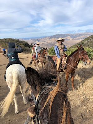
At which point we ran into friends Arturo and his son Rodrigo coming up the trail,. They had been invited to join us but had to finish a job first and so came late. We left them to finish their ascent, with gale warnings, and continued down.
To live in the crowded city, concerned about viral exposure and pandemic precautions, requires this antidote. Half an hour away and 2,000 feet up in the air, the world is peaceful and still.
Works for me!


"No hour of life is wasted that is spent in the saddle."
-   Winston Churchill


####### PAT FISH ######

## FIN ##


Sunday, December 20, 2020

2020/12/20 Winter Solstice stroll at the Monarch Grove and Deveroux Slough at Ellwood Mesa

Santa Cruz Island visible off the shore of the Ellwood Mesa. 

Winter Solstice and perfect bright climate (can't call it weather) beckoned to us to explore the shoreline and eucalyptus forests just North of UCSB.

We started out at the Ellwood School parking lot on the mountain side of Hollister Avenue, rode across the Mesa out to the cliff edge, proceeded South to check out the slough, then meandered back through eucalyptus groves and grass fields.
Five-ish miles in two-ish hours, just enough to stretch out the equines' legs and get us out in nature.

A section of the Ellwood Mesa has been set aside as a preserve for the Monarch Butterflies. Tragically, today we saw NONE.

Here are photographs taken there in 2011:


We used to see branches so covered with the orange magnificence that you couldn't see the green leaves they clung to.

And with a certain irony, the news headlines today read:


But in the year 2020, when everything that could go wrong seems to be, this is just another insult to injury. And there being nothing we can do about it, we went for a ride and enjoyed the day.
The path out to the Mesa skirts the edge of the eucalyptus trees that have been badly damaged by the droughts of the last few years.
With no effort made to water them the trees are on the verge of collapse, and with them will go the habitat the Monarchs relied on.
Once on the Mesa, the view of the Islands and the sea. The oil platform still dots the channel, and several more run up the coast, despite it being a marine sanctuary.
Once upon a time we used to be able to go down the cliffs to the beach and ride, but the Snowy Plover preservation plan has quashed that. One member of our group grew up boarding her horse nearby and riding wild through these trails, down onto the beach, being a thoroughly wild thing. As we walked the civilized paths she regaled us with tales of naked escapades and drunken near-death exploits.
Nature abides, and how wonderful to be out from behind a computer and seeing landscape stretching away in space.
                                                                This is the wicked little sign that forbids equines and dogs from going on the beach. In an age where people want to rat out their neighbor for not wearing a mask, we dare not trespass. 
And these are the oil tanks that offshore oil used to be pumped in to.
But after several spills, they were abandoned and this area became part of a "wetland restoration" project to "mitigate" the careless use of the land.
When I was last here 4 years ago this was a native plant propagation lab, filled with plants that were being transplanted out into this landscape. Now it seems abandoned.


This used to be a lush golf course, filled with men in absurd bright plaid outfits and little golf carts whizzing around.
                                                     This is my photograph of this same area in 2011. It was actually quite lovely.

NOW it is a deserted waste of trampled dirt.
Airplanes constantly growling above add to the post-apocalyptic feel.

Equines forget nothing. Does Tobe remember this as lush grass and disturbing golf carts?

Signs forbid entry and call it a restoration, but it looks like a defeat.

We are forbidden entry, but I say it all looks like it could use a delivery of manure compost to mulch these dried up bushes.


Then we followed the road out to look at the slough.

I may be sounding uniquely cynical in this commentary, but I found the sight of masks on so many people dreadfully sad.         Here they are, out in the fresh air, walking or bicycling alone, wearing a mask as if they believed the magic Virus could drift on a breeze and kill them.

And then, there it was, the slough. Almost dried up. A tiny trickle of water ran in a stream down the center. For comparison, here is a photo I took from near this viewpoint in 2011:
Few egrets hunting today, in what I had always seen as a rich ecosystem teeming with life.
 
I felt like a ghost in my own life.
But we all know you can't go home again, so it was onward with today's trail ride, time to turn back toward the starting point.
Which involved navigating not one but two metal span bridges that made more noise with every hoof step than any equine would like to hear.

Somehow this plover monument that bears a passing resemblance to male human anatomy felt like a big f-you to anyone who wanted to run amok on the beach with their horse or dog, or have a lush golf course at the seaside. Of course our native with childhood memories was doubly aghast, as she wondered where buildings like the old golf course club house had gone.


Just dried caked mud now.


And crackerbox housing

smashed densely together where once milkweed grew.

This is this field in 2011  

Ah, sweet Goleta, the formerly Good Land.

But before we left it was opportune to take some portraits of my trail companions, with Santa Cruz island as the backdrop.

Noe on Marcos

Maggie on Woodie

                                            Jamie on Mosca

                                           Deborah on Carbon

                                and I'm a bit of a blur on Tobe Mule

so I will close with this photo of us down on the beach in 2016

and here we are
making memories every day.
As the world spins in a pandemic, 
and nothing can be taken for granted,
least of all the measure of our days.


###### PAT FISH ######
### FIN ###