Showing posts with label Goleta. Show all posts

Saturday, October 8, 2022

2022/10/8 Ellwood Devereux Mesa Open Space Sojourn

The Ellwood Mesa is a coastal property, either 137 or 230 acres (depending on your source) that includes 10 miles of trails within the Ellwood Devereux Open Space, a 600 acre multi-agency parcel that includes open areas and reserves on UCSB’s North Campus and West Campus, lands within the University System’s Coal Oil Point Reserve, The Land Trust’s Coronado Butterfly Preserve and the City of Goleta’s Ellwood Mesa and Sperling Open Space.
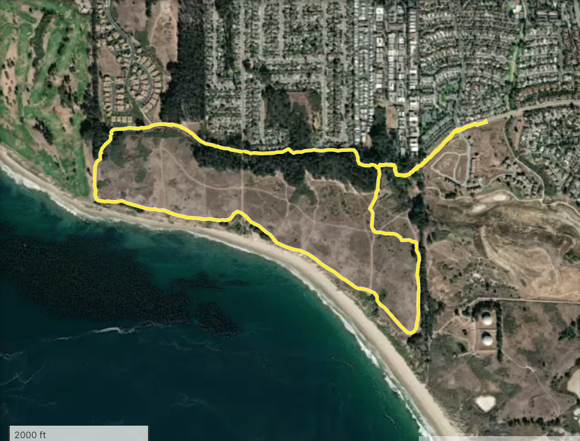
We took a ride with Los Padres Trail Riders to see how it is looking these days.

We parked at the end of Phelps Road, near Cannon Green, in Goleta. There is a long stretch of conveniently mulched wide parking, just right for horse folks to use. From there you can see on the map we went counter-clockwise through the eucalyptus forest that borders the housing development, went out on the edge of the Sandpiper Golf Course to the cliffs, walked along the sea toward UCSB, then turned back to our starting point.
For the first time on an equine adventure we were led by a bicyclist! Terry does not have a horse at present, but he isn't letting that stop him from being one of the herd!


At the beginning of the eucalyptus forest we are glad to tuck into the trails that take you through nature, away from the world of cement and close-packed housing surrounding it.


The eucalyptus have an allelopathic effect on other plants, so the understory is often covered with no other species, just their own shed off bark and leaves.

Some people dislike them because they are not native. I like them for their beauty, scent, and because they are a home for the monarch butterflies.

At the edge of the eucalyptus grove other plants immediately grow in profusion.


These strange cement structures line the path, an inconvenient opportunity for graffiti. 

TobeMule's ears are in the back position, indicating he's not happy about what it is he is looking at.

I couldn't read the graffiti either.


Another cement whatever, and above a splash of red in the leaves on the eucalyptus branch.

Palm trees in the distance in the housing area.

Wonderful that neighborhood kids have this free space to explore and play in.


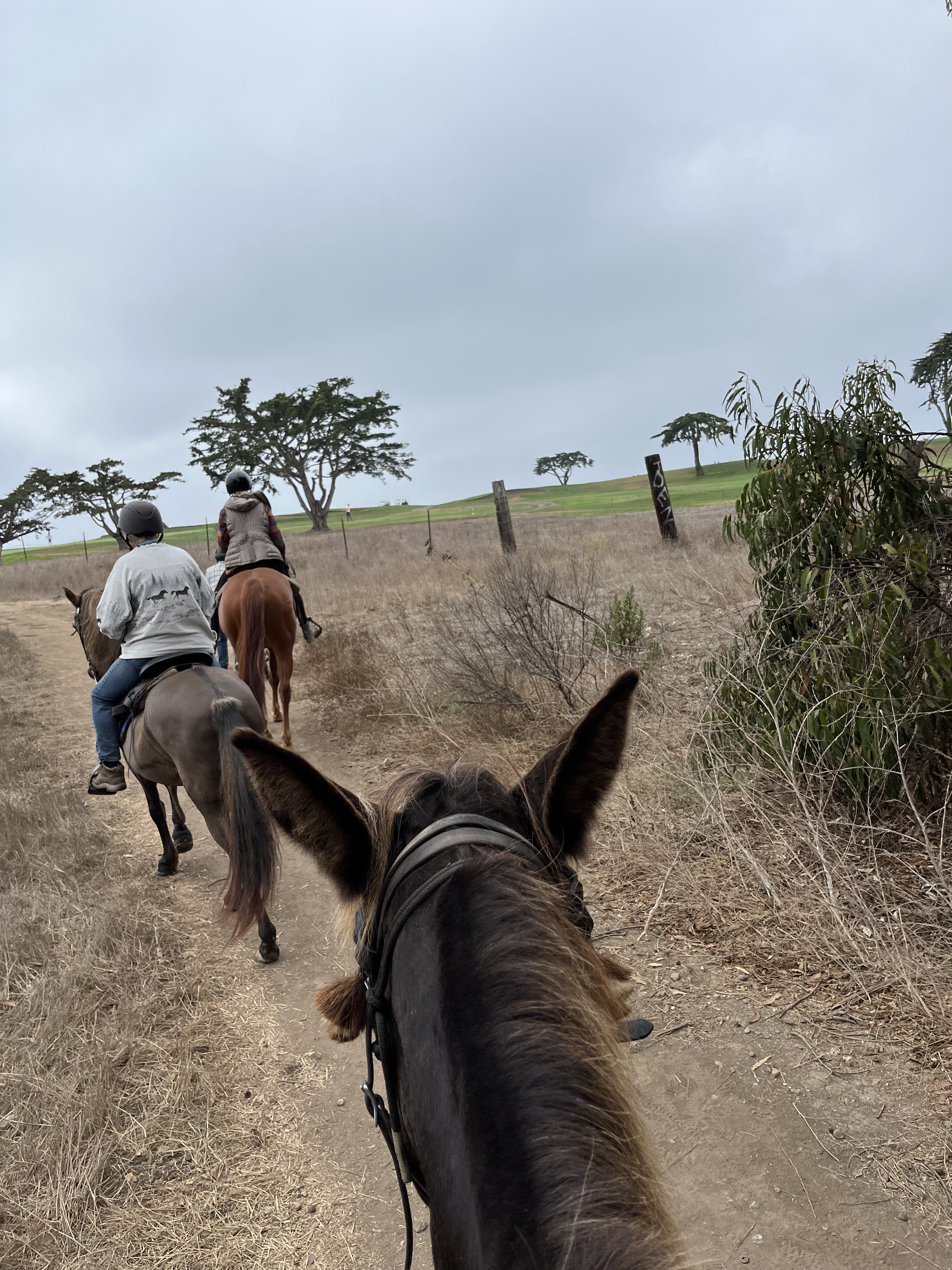
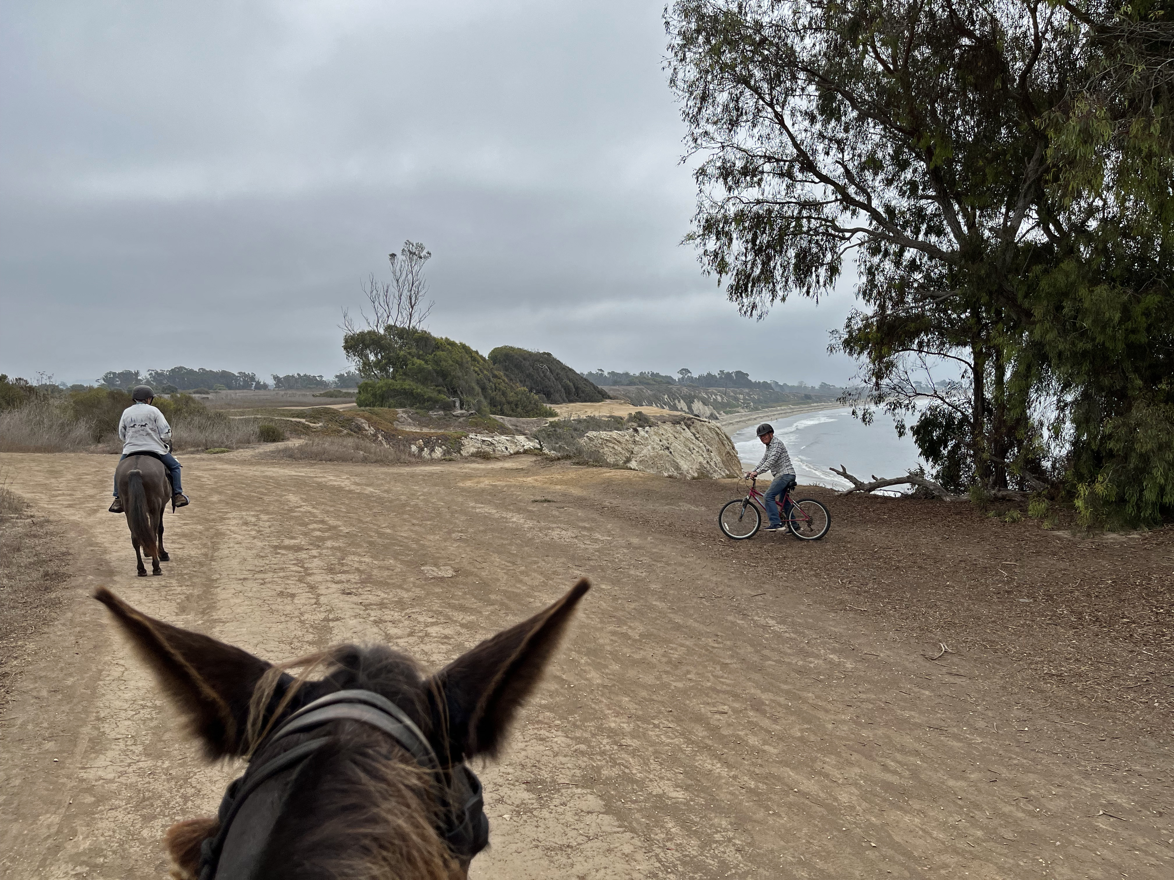
Here we are all spread out on the trail, with Terry pedaling along in the lead. 

Equines really are hard-wired to dislike any predatory behavior, so having the bicycle out in front removes their fear of something rushing up on them. 

We began to see lots of detritus under the trees on either side of the trail, many sawed off branches and trunks just left where they fell.

Interestingly, the very next day I read on EdHat that a large sum of money has been allocated to clean up the fire hazard this dead wood represents.


Clearly this needs to be done! 

Much as I am in favor of leaving things natural, I say get some draft mules in here and drag out the dead logs before some "unhoused neighbor' decides to set up an "encampment" and set the whole thing ablaze, burning up the butterfly preserve and the Ellwood Shores housing development.

Of course, like with anything Government, I am distressed by what They may define as an appropriate "defensible space." 


There are currently gates that prevent automobiles from sneaking in, but which could be opened for emergency personnel.


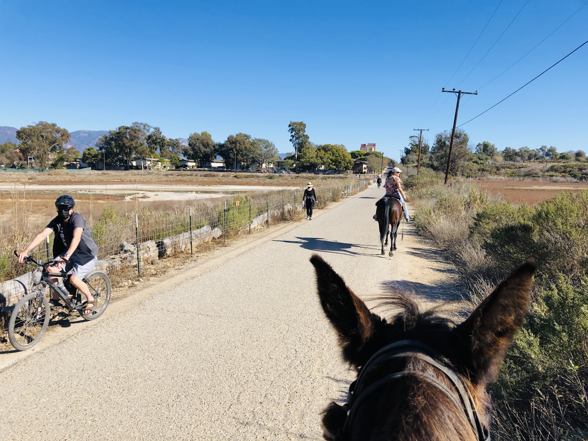
At this point it is a nicely maintained dirt path, wide enough for hikers, bike riders, equestrians all to share and pass each other with a nod and a smile.

 But with Government funding will they turn this into some sort of Class X Bike Path and defeat the purpose of inviting people to take a slow walk in a natural place?


Tobe and I look wistfully at this inviting bit of trail that would take us toward the beach.......

but it is off limits to equines.


If it will help the butterflies we can certainly go around it!


In years past I have often come here to see the miracle of the monarchs.

They are struggling now, but we can hope things will turn around for them and once again people can see the trees covered in living jewels and fluttering in the warm still air between the trees.

For now, the only other creatures we see today are dogs.
The rules say they are to remain on leash, but in at least half the encounters we have to wait and ask that the owners do the right thing. No matter how much they tell us "She loves horsies" it is just never appropriate for a dog to rush a horse. And being a dog lover myself I don't want to watch Tobe drop-kick one into the next life.


Then we turn the corner, and tread our way past the Sandpiper Golf Club. To see amazing drone footage showing the course click HERE

On February 23, 1942 the Imperial Japanese Navy's submarine I-17 surfaced and shelled the oil refinery at the Sandpiper site.

The championship golf course at Sandpiper has been rated by Golf Digest in the top twenty-five public golf courses in California and top 100 public courses in the Country. The course measures over 7,000 yards.


And next we met well-mannered people with a well-trained dog who stepped off the trail for our little parade to pass safely by.

We so appreciate it!

I am Scottish, so I hesitate to mock golf, but there it is. If you ARE going to spend hours whacking a little ball around, what a place for it !!!

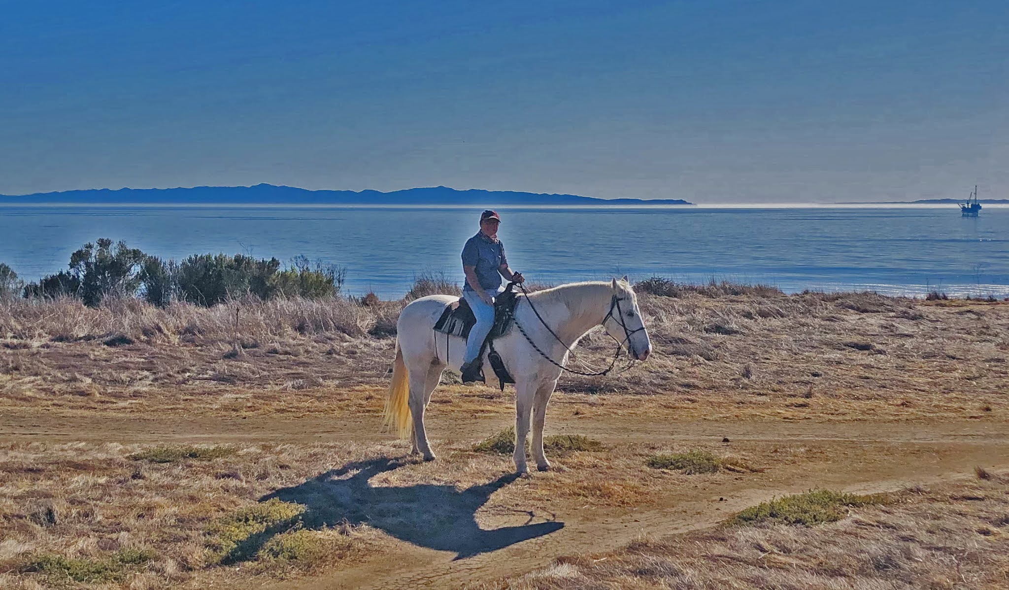
And finally we can see the sea.

Of course the air is clean and invigorating with negative ions. Negative ions, a name given to a small molecule that’s gained a negative electrical charge, are found in extremely high concentrations near the ocean. These molecules are microscopic and can not only pass through our skin cells but also through our lungs via the air we breathe.

The beach, in particular, can have as much as 2000 negative ions per cubic centimeter as opposed to a crowded city that may have less than 100.

Studies have shown that negative ions possess not only an anti-microbial effect but also a mood-stabilizing one. Research seems to indicate that negative ions can influence seratonin levels in your brain. Serotonin is a neurotransmitter that may have role in mood disorders ranging from depression to seasonal affective disorder.

So what better way to elevate your mood than a stroll on the cliffs. Except, Tobe and I agree that the path closer to the edge, well, we are all to aware of ground squirrel activity and if they built a rodent condominium in the underside of the cliff right where my rather large mule and I happened to walk.... could be a long slide down to the beach below.
I do like seeing the edge of the UCSB property far ahead on the shoreline. My alma mater, I had four happy years there on a full scholarship and now have BAs in both Studio Art and Film Studies. Not STEM, but life enhancing and relevant to my work as a tattooist.
That tiny speck in the maritime fog off of Ellwood is Platform Holly, one of several oil drilling rigs near the Santa Barbara Channel Islands.
Usually on a brighter day it would form a backdrop more like this for surfers.
And here is the whole riding krewe. From left to right: Colleen Beall on Teddy Quarterhorse, Terry Moore on his Schwinn bicycle, John McRoberts on Iva Arab, Debra McRoberts on Pocahontas Arab/Paint, and Nancy Moore on Jugueton Paso Fino.
Above us the ever-present, inescapable airplanes. A constant flow of planes coming and going, with the Santa Barbara International Airport very close by. The people living near by must be affected by the loud sound, I could not live under it.
But nothing to complain about when we are here for just a 90 minute stroll. Today we cannot hear the breakers below, nor smell the salt air, perhaps because of the fog. I only miss seeing the islands offshore, usually the visual bracket of my world here on the Edge of the Continent.
A note about the Moores. Nancy loves to ride, and since Terry's horse passed away he comes along on his bicycle so that she does not have to ride alone. That, my friends, is a loving husband.

And funny thing, after an hour of having Terry ride with us the horses are completely over any reactivity and he can be in the middle of the group with no issues. Good desensitization training.

Oh look, over there on the right, a pipe showing where a bit of cliff has fallen away! Yikes! We will stick to the inner trail, thank you.

On this stretch we ran into lots of dog people.


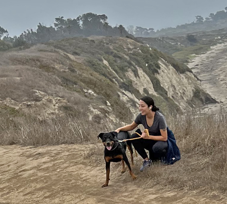
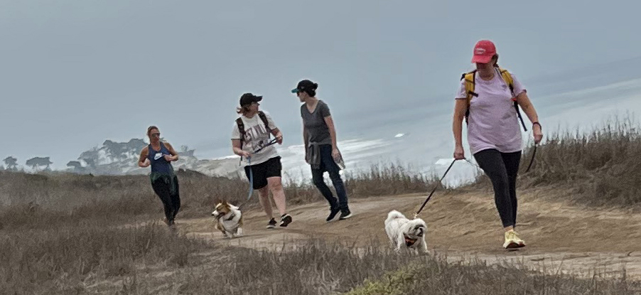
A very happy place for all animals!

But now it was time to turn inland and go back to the rigs.

Nice thing about these trails is that if there are hikers or bike riders you can see them clearly a long way off and easily share the paths.


Tobe is of the "look both ways before crossing" sort, so he keeps a wary eye in all directions and listens intently.


Here he is keeping a tilt to the left to avoid this spectacular erosion.


Surely this eroded zone has its own name? It should !


But soon our path winds back through a short part of the eucalyptus forest ....


And past this new housing development which has all sprung up since the last time I rode out here. So sorry to see open space converted to housing, but that's the way of it. 

We will continue in our celebration of the wild, whenever and wherever we can find it.

OOOOOOOOOOOOOOOOOO

“We need the tonic of wildness...At the same time that we are earnest to explore and learn all things, we require that all things be mysterious and unexplorable, that land and sea be indefinitely wild, unsurveyed and unfathomed by us because unfathomable. We can never have enough of nature.”
Henry David Thoreau,WALDEN: Or, Life in the Woods
 
OOOOOOOOOOOOOOOOOOO
 
<")#)><      Pat Fish
 
xxxxx FIN xxxxx


Sunday, December 20, 2020

2020/12/20 Winter Solstice stroll at the Monarch Grove and Deveroux Slough at Ellwood Mesa

Santa Cruz Island visible off the shore of the Ellwood Mesa. 

Winter Solstice and perfect bright climate (can't call it weather) beckoned to us to explore the shoreline and eucalyptus forests just North of UCSB.

We started out at the Ellwood School parking lot on the mountain side of Hollister Avenue, rode across the Mesa out to the cliff edge, proceeded South to check out the slough, then meandered back through eucalyptus groves and grass fields.
Five-ish miles in two-ish hours, just enough to stretch out the equines' legs and get us out in nature.

A section of the Ellwood Mesa has been set aside as a preserve for the Monarch Butterflies. Tragically, today we saw NONE.

Here are photographs taken there in 2011:


We used to see branches so covered with the orange magnificence that you couldn't see the green leaves they clung to.

And with a certain irony, the news headlines today read:


But in the year 2020, when everything that could go wrong seems to be, this is just another insult to injury. And there being nothing we can do about it, we went for a ride and enjoyed the day.
The path out to the Mesa skirts the edge of the eucalyptus trees that have been badly damaged by the droughts of the last few years.
With no effort made to water them the trees are on the verge of collapse, and with them will go the habitat the Monarchs relied on.
Once on the Mesa, the view of the Islands and the sea. The oil platform still dots the channel, and several more run up the coast, despite it being a marine sanctuary.
Once upon a time we used to be able to go down the cliffs to the beach and ride, but the Snowy Plover preservation plan has quashed that. One member of our group grew up boarding her horse nearby and riding wild through these trails, down onto the beach, being a thoroughly wild thing. As we walked the civilized paths she regaled us with tales of naked escapades and drunken near-death exploits.
Nature abides, and how wonderful to be out from behind a computer and seeing landscape stretching away in space.
                                                                This is the wicked little sign that forbids equines and dogs from going on the beach. In an age where people want to rat out their neighbor for not wearing a mask, we dare not trespass. 
And these are the oil tanks that offshore oil used to be pumped in to.
But after several spills, they were abandoned and this area became part of a "wetland restoration" project to "mitigate" the careless use of the land.
When I was last here 4 years ago this was a native plant propagation lab, filled with plants that were being transplanted out into this landscape. Now it seems abandoned.


This used to be a lush golf course, filled with men in absurd bright plaid outfits and little golf carts whizzing around.
                                                     This is my photograph of this same area in 2011. It was actually quite lovely.

NOW it is a deserted waste of trampled dirt.
Airplanes constantly growling above add to the post-apocalyptic feel.

Equines forget nothing. Does Tobe remember this as lush grass and disturbing golf carts?

Signs forbid entry and call it a restoration, but it looks like a defeat.

We are forbidden entry, but I say it all looks like it could use a delivery of manure compost to mulch these dried up bushes.


Then we followed the road out to look at the slough.

I may be sounding uniquely cynical in this commentary, but I found the sight of masks on so many people dreadfully sad.         Here they are, out in the fresh air, walking or bicycling alone, wearing a mask as if they believed the magic Virus could drift on a breeze and kill them.

And then, there it was, the slough. Almost dried up. A tiny trickle of water ran in a stream down the center. For comparison, here is a photo I took from near this viewpoint in 2011:
Few egrets hunting today, in what I had always seen as a rich ecosystem teeming with life.
 
I felt like a ghost in my own life.
But we all know you can't go home again, so it was onward with today's trail ride, time to turn back toward the starting point.
Which involved navigating not one but two metal span bridges that made more noise with every hoof step than any equine would like to hear.

Somehow this plover monument that bears a passing resemblance to male human anatomy felt like a big f-you to anyone who wanted to run amok on the beach with their horse or dog, or have a lush golf course at the seaside. Of course our native with childhood memories was doubly aghast, as she wondered where buildings like the old golf course club house had gone.


Just dried caked mud now.


And crackerbox housing

smashed densely together where once milkweed grew.

This is this field in 2011  

Ah, sweet Goleta, the formerly Good Land.

But before we left it was opportune to take some portraits of my trail companions, with Santa Cruz island as the backdrop.

Noe on Marcos

Maggie on Woodie

                                            Jamie on Mosca

                                           Deborah on Carbon

                                and I'm a bit of a blur on Tobe Mule

so I will close with this photo of us down on the beach in 2016

and here we are
making memories every day.
As the world spins in a pandemic, 
and nothing can be taken for granted,
least of all the measure of our days.


###### PAT FISH ######
### FIN ###